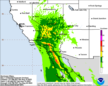
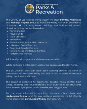
I am doing CHOC Walk on Sunday. I have collected my donations, so I don't think that would change. People make the donations online in support of a walker. Right now, CHOC has announced the walk in on --- rain or shine. So I am still planning for it. Just watching the weather closely and planning for the rain (getting out rain jacket and umbrella). It is sad since this is the first walk since 2019!
You are using an out of date browser. It may not display this or other websites correctly.
You should upgrade or use an alternative browser.
You should upgrade or use an alternative browser.
Hurricane Hillary headups- Sunday 8/20
- Thread starter clallen72
- Start date
Pluto468
DIS Veteran
- Joined
- Mar 11, 2020
Hopefully the storm will weaken before it gets anywhere near Anaheim. When I lived in LA rain wasn't common and, as said above, alot of people just don't know how to deal with it, especially driving in it. I remember one year there were a number of fender benders on the highway because the roads were slick and people were trying to see rainbows while they drove. Other things were more serious, like cars being swept away in flash floods. So if anyone is driving to the parks and it's wet, just take extra care.
FeliciaB23
Mouseketeer
- Joined
- Feb 23, 2016
As for the stores being full stocked, we are used to weather people blowing these storm watches out of proportion. They really do take it to ridiculous levels and 9 times out of 10 the weather ends up being non-eventful. So we are trained to ignore all the dire warnings.
I live in NJ, at the Jersey Shore to be specific. In 2011, we were warned about Hurricane Irene, which ended up being nothing major. In 2012, we were warned about Hurricane Sandy and because Irene was so minor, thousands of people didn't take the storm seriously. I hope SoCal isn't badly affected but, just a friendly heads up to listen to the meteorologists, it's better to be safe than sorry.

theluckyrabbit
DIS Veteran
- Joined
- Jul 23, 2012
We'll be there, too! Planning on rain jackets and waterproof shoes. Hoping we won't need the rain pants.I am doing CHOC Walk on Sunday. I have collected my donations, so I don't think that would change. People make the donations online in support of a walker. Right now, CHOC has announced the walk in on --- rain or shine. So I am still planning for it. Just watching the weather closely and planning for the rain (getting out rain jacket and umbrella). It is sad since this is the first walk since 2019!
joseph821
DIS Veteran
- Joined
- Jul 18, 2007
You will need rain pants. I live on the East Coast and I have lived through many hurricanes and tropical storms. It is not like regular rain. It will be bad. Windy and lots of pouring rain and thunderstorms.We'll be there, too! Planning on rain jackets and waterproof shoes. Hoping we won't need the rain pants.
joseph821
DIS Veteran
- Joined
- Jul 18, 2007
The Walk will likely be canceled beacuse of the storm and because of liability and insurance requirements. Plus the LA and Orange County will not want people on the roads. I lived in SO CA for 3 years and SO CA roads stop to a crawl in regular or small amounts of rain. SO CAL are not used to driving in rain let alone a tropical storm. Stay safe!We'll be there, too! Planning on rain jackets and waterproof shoes. Hoping we won't need the rain pants.
skellinton
DIS Veteran
- Joined
- Oct 26, 2005
Wow. Everyone down there stay safe.
I live in Oregon/Washington and am super used to rain storms, but obviously nothing as severe as what could be coming. Even here people drive like nitwits in the rain, but at least we have experience and I think our roads are better equipped for draining or runoff. I know when I was in LA for a wedding and there was what we consider light rain I was shocked at how much standing water was on the roadways.
I hope everyone stays safe.
DisneyRita
Earning My Ears
- Joined
- Jun 22, 2023
Oh gosh no- it doesn’t rain here very often.Does Disneyland do the Rainy Day Parade like DisneyWorld does?
Dug720
See the line where the sky meets the sea?
- Joined
- Feb 16, 2012
On the plus side, with the 3am update the storm looks to be tracking even further east. LA is totally out of the cone and Anaheim is almost out of the cone.
(Having lived in NC for years and now NYC for years, I’m very used to tracking these things.)
(Having lived in NC for years and now NYC for years, I’m very used to tracking these things.)
LKing
DIS Veteran
- Joined
- Mar 3, 2023
@Dug720 what resource are you using to track the storm? Remember, Disneyland is in Anaheim, not Los Angeles.
According to NOAA, Anaheim is within the cone. You can zoom in and out to see where Anaheim is located on this map: https://www.nhc.noaa.gov/refresh/graphics_ep4+shtml/115409.shtml?gm_track#contents
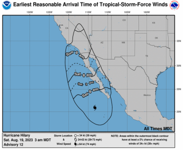
This is the estimated timeline for wind arrival on NOAA as of 3:00 am MDT on Saturday.
According to NOAA, Anaheim is within the cone. You can zoom in and out to see where Anaheim is located on this map: https://www.nhc.noaa.gov/refresh/graphics_ep4+shtml/115409.shtml?gm_track#contents
This is the estimated timeline for wind arrival on NOAA as of 3:00 am MDT on Saturday.

Last edited:
foolish_mortals
Mouseketeer
- Joined
- Oct 7, 2021
Please remember the cone only shows the track for the center of the storm.
Hurricane force winds extend 50 miles from the center and tropical storm force winds extend 265 miles from the center.
As the storm weakens the wind field will be wider albeit with less intensity. As it becomes lopsided the winds will vary greatly by quadrant which is why a shift west or east could mean drastically different wind and rain in the forecast.
The wind arrival time and speed probabilities map are better tools for tracking how much this storm will affect you.
Dug720
See the line where the sky meets the sea?
- Joined
- Feb 16, 2012
That is the site I am using (I am well familiar with tracking them). The track is actually a line in the middle of the cone - the cone is the whole possible area.@Dug720 what resource are you using to track the storm? Remember, Disneyland is in Anaheim, not Los Angeles.
According to NOAA, Anaheim is within the cone. You can zoom in and out to see where Anaheim is located on this map: https://www.nhc.noaa.gov/refresh/graphics_ep4+shtml/115409.shtml?gm_track#contents
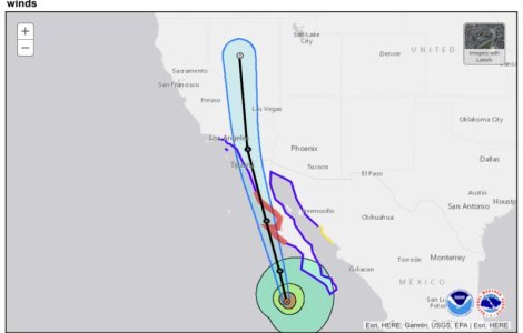
As of the 9am update.
And zoomed in showing Anaheim which is outside the cone as of the 9am update.
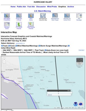
And obviously be prepared, but if trends continue as they have Anaheim should not have it too horrible.
Last edited:
kristensideaoffun
DIS Veteran
- Joined
- Apr 14, 2014
It sounds like Southwest is canceling/rescheduling a lot of incoming San Diego flights. I won’t be surprised if the airport shuts down at least temporarily tomorrow. It only has one runway and they often have to change the direction of take-off and landing based on fog and wind on days without extreme weather like this.
LKing
DIS Veteran
- Joined
- Mar 3, 2023
I was thinking the same thing about LAX, LGB and SNA. Even if they can take off to the west, they're going to have go pretty far north before they can turn east.It sounds like Southwest is canceling/rescheduling a lot of incoming San Diego flights. I won’t be surprised if the airport shuts down at least temporarily tomorrow. It only has one runway and they often have to change the direction of take-off and landing based on fog and wind on days without extreme weather like this.
This map shows the likelihood of tropical storm, which includes all of SoCal and southern Nevada.
This map shows the probable path of the eye of the storm.This is the estimated timeline for wind arrival on NOAA as of 3:00 am MDT on Saturday.

Expect lots of rain. Stay in the bubble.
As of the 9am update.
And zoomed in showing Anaheim which is outside the cone as of the 9am update.
irlandaise
DIS Veteran
- Joined
- Sep 27, 2022
Yeah, Southwest is warning of possible disruptions at California airports as far north as Santa Barbara:I was thinking the same thing about LAX, LGB and SNA. Even if they can take off to the west, they're going to have go pretty far north before they can turn east.
- Burbank, CA - BUR
- Las Vegas, NV - LAS
- Los Angeles, CA - LAX
- Long Beach, CA - LGB
- Ontario, CA - ONT
- Orange County/Santa Ana, CA - SNA
- Palm Springs, CA - PSP
- San Diego, CA - SAN
- Santa Barbara, CA - SBA
RoseColored97
DIS Veteran
- Joined
- Jul 2, 2022
Yikes, stay safe everyone!
Sykes
DIS Veteran
- Joined
- Jun 1, 2017
That cone only shows the forecast uncertainty regarding the center of the storm (i.e. the center of the storm could be anywhere in that cone) and is mostly meaningless for understanding the extent of the impact because that varies significantly depending on the size of the storm. The extent of tropical storm force winds (and other impacts of the storm) will be well beyond the cone.That is the site I am using (I am well familiar with tracking them). The track is actually a line in the middle of the cone - the cone is the whole possible area.
And obviously be prepared, but if trends continue as they have Anaheim should not have it too horrible.
-
New Wolverine & Throwback X-Men Merch Early Disney+ Access
-
Why So Much Negativity Toward Disney IP When People Clearly Love It?
-
Two Restaurants Added to Fantasmic! Dining Package at Disneyland
-
Wine Bar George Makes Top 100 Best Brunches on OpenTable
-
Disney's Coronado Springs Resort - Standard Room Tour in 3D / VR
GET A DISNEY VACATION QUOTE
Dreams Unlimited Travel is committed to providing you with the very best vacation planning experience possible. Our Vacation Planners are experts and will share their honest advice to help you have a magical vacation.
Let us help you with your next Disney Vacation!
Dreams Unlimited Travel is committed to providing you with the very best vacation planning experience possible. Our Vacation Planners are experts and will share their honest advice to help you have a magical vacation.
Let us help you with your next Disney Vacation!
New DISboards Threads
- Replies
- 1
- Views
- 44
- Replies
- 0
- Views
- 63
- Replies
- 14
- Views
- 117
